The Code of the Piri Reis Map interview
Mr.Metin Soylu Writer – Researcher The Code of the Piri Reis Map interview
SPECIAL INTERVIEW
THE PIRI REIS PROJECT
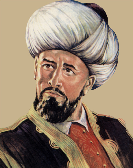
Piri Reis, who created a stir in the scientific world with his mysterious world map he drew in 1513, is on thea genda again after 500 years. The year 2013 has been proclaimed the Year of Piri Reis by UNESCO (United Nations Organization for Education, Science and Culture), so we asked the code of the ancient map of 500 years to Metin Soylu who has been studying the map of Piri Reis since 1998 and who is known as the author of the book "The Code Map of Piri Reis. " Soylu, revealing a great truth about the world map of Piri Reis drawn five centuries ago, says that "The whole world should know that the Piri Reis map was drawn with the technique of photography taken from space."
- How did the research of Piri Reis start?
Metin Soylu: Everything started in 1997 with a magazine that a friend of mine brought to class with him while I was a student at the "Ankara Batikent Mobil Lisesi”. The article in this magazine was very interesting: “The secret of the Piri Reis map can not be resolved!”. The article dealing with the life and the unjust execution of Piri Reis also contained the details of the map drawn by Piri Reis in 1513. This article also had the Piri Reis map. I found the topic very interesting. I started researching on Piri Reis, first in the school library, then in every library I went.
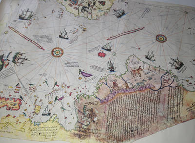
Here is what I found out about this map.: This world mapwas drawn in 1513, but it was fragmented. When it was discovered in the Topkapi Palace on 9 November, 1929 there were bread crumbs and food on the map. Obviously, someone had dined on the map. In today's language, it was used as a "tablecloth". When Halil Ethem, who was director of the Museum at the time, communicated the news to the Great Leader Mustafa Kemal Ataturk in the same week, the map was brought to the presence of Atatürk..
Thus, doing research every day on the Piri Reis map interested me most, the only thought in my mind was to investigate this matter, to create a project out of it …
There were almost 3 months left to graduate from high school in 1998. One day I went to the history teacher and said I wanted to do research that I named the "Project of Piri Reis". I told him that I had found the clues that would allow me to complete the fragmented world map of Piri Reis. I asked him whether the school administration would support my project.
The history teacher told me that it would be best to write a letter of request to the principal. which I did. The school administration gave importance to the subject, but we could not find a spare room owing to the physical conditions of the school, this was the only problem. There was also the issue of time, I would have graduated in 3 months. For that reason, our director told me to go to the Ministry of Education by saying: “It will be better to refer to the Ministry of Culture or the Ministry of Education. At least, after graduation, if they give you the opportunity, you can continue your research in more reliable conditions”. In a short time, I decided to offer this project to the Ministry of Education. With the support of Hikmet UluĂ°bay, who was the Minister of Education at the time, I officially started the "The Piri Reis Project".
--We know that you have completed the world map of Piri Reis for the first time in history with the principle of induction. How did you do it?
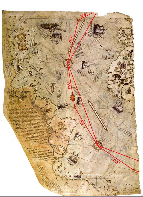
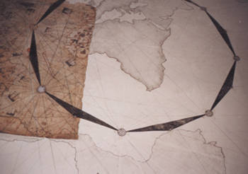
Metin Soylu: Due to the results of my research on the detailed map of Piri Reis, who had been fragmented to date by purchasing a copy of the original map (size: 90x65cm) I started my project. I must admit in all honesty that I completed the map only after eight and a half months. Completing the fragmented Piri Reis map thanks to the principle of induction, I found myself with a series of amazing facts. I found a mathematical calculation based on five round shapes, two adults and three children who are in the middle of the Atlantic Ocean on the map. According to this calculation: There are 44 degrees between the two big shapes and between two round shapes a large and the other small; there are 22.5 degrees from center to center 22,5 x16=360 degrees (He also found the circumference of the world!)
On 14 October 1999, through the Ministry of Foreign Affairs, I sent to NASA The World Map of Piri Reis of 36 square meters that I had completed.
In your view, the Piri Reis' map that you have completed, was similar to the map drawn in that century?
Metin Soylu: Surely it was so, because it was told so, in the poem entitled "Declaration of the Map" in the "Book of the Sea" by Piri Reis.
Declaration of The Map
They divided in sixteen sections, believe me,
The center fully evident,
From one to another of these sixteen sections,
Who draw lines properly
Calculating two ends of a line,
It comes found response that two part of thirty-two,
Listen now that science of map,
So that you know the condition ...
The Book of the Sea - Volume-1 Page: 82
-Then, you have received a response from NASA?
Metin Soylu: Sure ... About four years later, NASA has sent an explanation to the Turkish and German magazine Focus. I read the New Shape of the World in the news and I realized that Piri Reis was right. However, in the news, there was not the name of Piri Reis. NASA had published the news as if it were the result of our research.
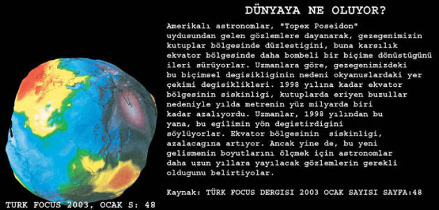
WHAT ĂťS HAPPENĂťNG TO THE EARTH?
The American astronomers suggest that, on the basis of observations from satellites "Topex Poseidon", our planet straightens up in the poles and Whereas, in equatorial changes in a more convex. The cause of this formal change in our planet gravitational changes in the oceans. Up to one hundred billionth of a meter per year decreasing until 1998. This is due to the equatorial bulge and the melting poles glacier. Experts since 1998, said that the slope has changed direction. The equatorial bulge is increasing instead of decreasing. However, astronomers say, to measure the size of this new development, it is necessary to observe for many years.
QUOTE: TURKISH JOURNAL FOCUS 2003 - January - p. 48th
- What were the other truths that have been revealed by Piri Reis' map ?
Metin Soylu: The main results are the following:
World map by U.S. Air Force azimuthal equidistant projection center, Cairo has been identified as the central. And Admiral Piri Reis, in 1517 in Egypt shipment of Yavuz Sultan Selim, leading the ships, went to Cairo and drew the map of the sources of the Nile River. The argument on which we should concentrate, is the truth that Piri Reis, drawing, also showed the Pyramids of Egypt in its map. This indicates that Piri Reis drew his world map leading to the Pyramids of Egypt as a central and too many centuries ago, had chosen Cairo as did the U.S. Air Force. Because in 1517 he participated in the expedition to Egypt, and had done research on the Pyramids in Cairo. This truth can be understood from the map drawn by him in Cairo. If you look carefully at the map of Cairo, at the top right, you can see the design of the famous pyramids of Cheops, Chephren and Mikerinos.
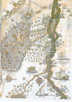
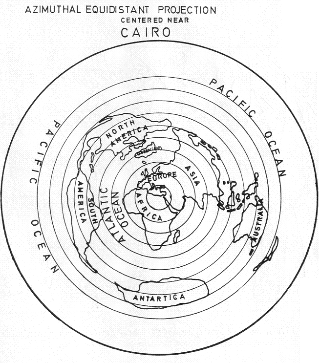
the exact center of the Piri Reis map that I completed, indicates CAIRO
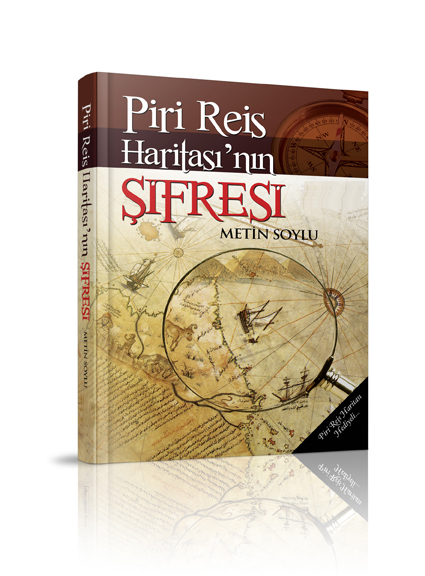
- There is an interesting discovery in his book titled "The Code Map of Piri Reis. You say that that this work Piri Reis had drawn in 1513 is not a map. So, if it is not a map, what does this drawing mean?
Metin Soylu: One of the most amazing events that I met after completing the map, was "reaching the truth" that the work known as the "Map of Piri Reis" is not a map, indeed, it is almost a photo. It is known that a map is the method to show on a two-dimensional plane with the lines detail apparently the earth top view of reducing to a certain extent. Geographically, we need some features so that you can nominate as a map. These characteristics are the following:
I. Being in a reduction of scale,
II. Having bird’s eye view (Full hill view)
III. Being transferred to a plane,
IV.Containing geographical elements to display.
Argentina is displayed vertically in the maps of the world transmitted to a plane.
However, if you look carefully at the map transferred to the plane, you can see the Argentina which is located in the southern part of South America, extends vertically. The reason for this is that the map is transferred to the plane. So, to have a map function, necessarily must be transferred to the plane. Let's look at the following images of the Earth taken from space:
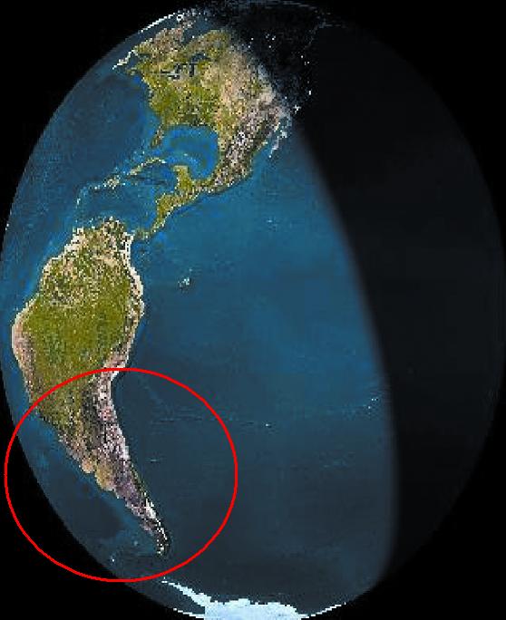
In satellite photographs taken from space, due to the rotation the Earth has a continuous process. However, while the Earth moves in which we live, as a result, they turn even continents. If we look at Argentina in the line of South America, we can see that Argentina is curved to the right, it means; it turns.
Now let's look to the map drawn by Piri Reis in 1513; perhaps to the photo. If you look on line to Argentina in South America on the map drawn by Piri Reis, you witness the fact that Argentina is curved to the right. Thus the picture in which Argentina is curved to the right, is completely equal to the satellite photographs taken from space.
So, as I said before, if these are the photographs taken from space, also the fact that being curved in the Piri Reis map is a snapshot? How did he know; Admiral Piri Reis this truth being Argentina curved, which can be perceived only in space?
Starting from these truths in Piri Reis' map, it is concluded that this design can not be a map, it is designed with the technique of taking pictures from space.
In photographs taken from space, the Strait of Gibraltar is shown on the next page. However, looking in detail the appearance of the Strait of Gibraltar, being correct of this image is a detail only by including pictures taken from space. We need to look from a bird’s eye for both the depth of the Strait, and the narrow passage between the two parts. If we look at the "Map of Piri Reis" we can achieve interesting results. The two photographs of the Strait of Gibraltar taken from space and the Strait of Gibraltar on the Map of Piri Reis are identical.Do you think the knowledge of Piri Reis of these details was a coincidence ?
Over the centuries, the existence of the Antarctic ice-covered mountains, was discovered by American and Russian marine researchers in 1820 by using crews that reflect the voice. These glacial mountains, existed in Map of Piri Reis who had not travelled round the world. So, how can it be explained, this detail? In those ages had any galleon (wooden ship) been able to reach the mountains of ice?(look at: The Code of the Piri Reis Map page: 115)
As is known, the maps of the world transmitted to the plan, there is a fusion between the continents between Argentina and the Mountains of Antarctica because between two extremes lies the ocean. However, due to the results of studies carried out by Russian researchers, it is identified that two extremes of Argentina and the sharp and steep mountains under the sea of Antarctic are joined. (look at: The Code of the Piri Reis Map page:116-118)
In fact, it is very difficult to identify this fact, which can be seen only by removing the water ball. If you look again at the map of Piri Reis, we see the same truth. This fact is surprising that the admiral Piri Reis was able to remove the water ball. How can you explain the fact that combine estremite of Argentina and Antarctica, that Piri Reis knew without technology?
I wish all the people in the world knew these facts discovered on the Map of Piri Reis. For that reason, I can accept all proposals of the conference both in Turkey and abroad. Also thank you for this valuable interview.

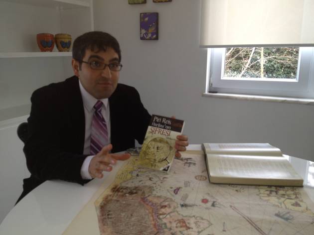
The mystery that Piri Reis who was one of the symbol names of the one of the symbol names of Turkish and International maritime history left behind is being dissolved. This book is a product of seven years of study of the author on the map of Admiral Piri Reis whostarted with a map known all over the world. The author disclosed a fact that surprised even academic circles. Metin Soylu’s research of the Piri Reis Map began many years ago as a hobby, which then turned into an adventure that reached the Ministry of Education and the Ministry of Foreign Affairs and then the NASA (National Institute for Space activities and Aeronautical). In this adventure, the relevant facts are initiated with the completion of the first fragmented map of Piri Reis and the consequences have surprised even the author.
This book offers interesting knowledge for readers to discover the mysteries of fascinating historical works and for those who dare to look at the world from an unusual perspective. Why was Piri Reis, who was the author of 'The Book of the Sea' and designer of the World Map and who had achieved a number of successes in maritime, was sentenced to death at the age of over 80 after having successfully served the Ottoman Empire? What had Admiral Piri Reis tried to find in Egypt, which he referred to as the Centre in his map? How did he draw his map? What was the relationship between his map and the Prophet Suleiman? Where had he hidden his treasure mentioned in his books? Was it Christopher Columbus who had explored America? Researcher-Specialist Metin Soylu, pursues the answers to these questions. Those who are curious about the life of Piri Reis will not be able to put down this book, they will be able to read about his life full of success, mysteries, explorations and adventure that was engraved with the name "Turkish" in the maritime world.
METĂťN SOYLU
(Journalist-Researcher)
He was born in Istanbul in 1981. He finished primary and secondary school at "Ankara Batikent Kursad Bey ĂťlköĂ°retim Okulu", and then in 1998 graduated from "Ankara Batikent Mobil Lisesi" (high school).
During his second year in high school, Soylu did research about the life and the map of the famous Turkish sailor Piri Reis out of curiosity. In order to further his studies and gain support for his research, he submitted a proposal for a project to the Ministry of Education in Turkey. After graduating from igh school, thanks to financial support from Hikmet UluĂ°bay, the then Minister of Education, he conducted research titled "Project of Piri Reis" at the General Directorate of Educational Technology of the Ministry of Education. Metin Soylu continued to study and do research on the life of Admiral Piri Reis for about seven years.
The young researcher who has completed the World Map of Piri Reis for the first time in the world, shared the results of this research with the public in his conference in the Middle East Technical University (METU-ODTU) held in August 10, 1999. On October 14, 1999 he sent his project to NASA (U.S. Aeronautics and Space Agency) through the Ministry of Foreign Affairs. Researcher Soylu decided to collect his studies about the life and the World map of Turkish admiral Piri Reis in a book, so he made a contract with Truva Yayýnlarý (Truva Publishing).
Metin Soylu, who meets his readers with his book titled "The Code Map of Piri Reis (Piri Reis Haritasýnýn Þifresi)"gave numerous conferences on the subject of Piri Reis in many universities such as the University of Kocaeli, Gazi University, University of Dumlupinar, University of Yýldýz Teknik and has had a big impact.
OTHER WORKS
With the publication of the the School Project for Disasters after the Marmara earthquake in August 17, 1999 in order to make the Turkish people become more aware of natural disasters and, above all with the aim of making students play a more active role in society as an individual emergency Volunteer, he gathered his thoughts on this in his book entitled "Afet Okulu (School of Disaster)". With the slogan "The Greatest Voluntary Action in Turkey", and with the establishment of a website by the name of www.afetokulu.com he initiated studies on the public. The last work of Metin Soylu as a writer researcher is "Yüzbaþý Muzaffer Mehmet" which is a true life story of heroism on the basis of the documentation.
Translated by Esma Tugce Tozman (Filologist from Ankara University)


 Piri Reis'in Ăžifresi-ĂťNGĂťLĂťZCE